Browse
···
Log in / Register
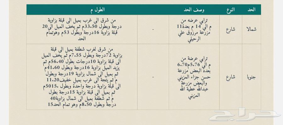

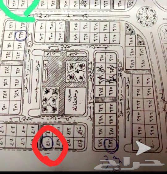
Property information according to the license Type of property: Land Property area: 34092 Street width: 30 Property frontage: Four streets Property services: Electricity, Waters, Sanitation, FixedPhone, FloodDrainage, FibreOptics Property boundaries and lengths Northern boundary type: Street Northern boundary description: Dirt road, width from 11m to 14m, adjacent to Marzouq Ali Al-Rahili's farm Northern boundary length: From east to west, inclined toward qibla at an angle of 20 degrees and length of 33.50m, then the inclination toward qibla decreases at an angle of 16 degrees and length of 53m, completing the boundary Eastern boundary type: Street Eastern boundary description: Paved road, width from 10.18m to 10.29m, adjacent to elevated vacant land and partly a cemetery Eastern boundary length: From qibla to north, inclined westward at an angle of 21 degrees and length of 44m, then the inclination westward decreases at an angle of 5 degrees and length of 14.55m, then proceeds directly north for 100m, then slightly inclined westward at an angle of 3 degrees and length of 113.40m, completing the boundary Western boundary type: . Western boundary description: Wadi Al-Aqiq Western boundary length: From qibla to north, inclined eastward at an angle of 4 degrees and length of 54.30m, then the inclination eastward increases at an angle of 19 degrees and length of 68.10m, then the inclination decreases at an angle of 14 degrees and length of 36m, then the inclination eastward increases at an angle of 40 degrees and length of 46.70m, then proceeds toward north with a slight inclination eastward at an angle of 14 degrees and length of 50.70m, then the inclination decreases at an angle of 3 degrees and length of 32.50m, completing the boundary Southern boundary type: Street Southern boundary description: Dirt road, width from 6.70m to 5.76m, adjacent partly to Hassan Jaza Al-Muzaini's farm and partly to Abdullah Atiyah Allah Al-Muzaini's farm Southern boundary length: From east to west, sloping toward qibla at an angle of 72 degrees and length of 7.55m, then the slope toward qibla decreases at an angle of 10 degrees and length of 56.40m, then the slope increases at an angle of 16 degrees and length of 41.60m, then inclined toward north at an angle of 19 degrees and length of 11.20m, then proceeds westward with a slight slope toward qibla at an angle of 1 degree and length of 15.50m, then inclined toward qibla at an angle of 15 degrees and length of 40m, then sloping toward north at an angle of 15 degrees and length of 8.50m, completing the boundary Price: 8523000